In preparing for touring in Ireland, and while riding there, I found the following invaluable:
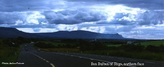
Unloading my bike at the Sligo railway station I blinked in the sunlight, a welcome change from the rain that had accompanied us most of the way from Dublin. As we exited the platform to the alley behind the station, there, shining an incredible green, was the unmistakable profile of Ben Bulben. My traveling companion Brian immediately launched into song, giving a lively if ill-tuned chorus of "Ben Bulben of Sligo, majestic ye stand, to welcome me home from my travels...."
From the railway station we navigated the downtown core, which was packed with cars on this beautiful late summer day. The streets we traveled were a veritable history of revolution in Ireland, and Brian, well-versed in Irish history, knew all the names: Wolfe Tone Street, O'Connel Street, Markeivicz Road. . .
After stopping at a bakery for a lunch of fresh bread and pastries filled with unequaled Irish cream, we set out on the N15 towards Drumcliffe, eager to leave the congestion of the town. Nearing the edge of town we asked directions from a man walking along the road, but he was not sure which road would take us to Donegal, never having been that far himself. Pulling out the ordnance survey map we made our way out of town, ending up for a time on a road that paralleled the one we wanted, until at last a small cross-lane let us get back on course.
Shortly after leaving Sligo, we stopped at the Drumcliffe churchyard to see the grave of W.B. Yeats, surely a modest resting place for such a great writer. The church was more interesting than the grave, having beautiful woodwork and huge brass swans as door pulls. The whole church and graveyard felt dwarfed by the imposing presence of Ben Bulben and King's Mountain.
After a few minutes and a snack we got back on the road, staying on the N-15 much of the way to Ballyshannon. The riding was easy and the road almost perfect. Despite warnings of heavy tourist traffic we had no difficulties apart from the occasional very light rain. The rain was picking up as we entered the town of Bundoran, a crowded seaside resort town. We decided to stop for more food. Ignoring the many fast food restaurants, we ate at another bakery, and waited for the rain to lighten.
(As an aside, Irish bakeries are close to heaven for bicycle tourists, filled with freshly-baked breads and sweets, everything cooked up that morning with the best butter on Earth. When you've been riding through the countryside much of the day you can smell the distinctive tang of a bakery more than a mile away. Besides having great food, bakeries are warm in cold weather, open earlier than most shops, and are central to the life of even the smallest town, so a stop at a bakery can quickly produce invitations to dinner, directions to another town, or advice about camp sites.)
Back on the road after less than half an hour, we continued in a light drizzle but calm winds north on the N-15 most of the way to the small town of Ballyshannon. In Ballyshannon we turned off for Rossnowlagh on the smaller R231, and in Rossnowlagh we turned again to rejoin the N-15 just south of Donegal town. The rain had stopped, and the fields were a brilliant emerald against the dark sky. Behind us Ben Bulben continued to dominate the landscape.
We entered Donegal Town about dinner time, and stopped at a store for dinner makings. After some indecision we settled on canned Irish stew on rice. (Rice is one of my touring staples -- it keeps forever if you keep it dry, and if you forget to pick up supplies you can cook rice with the water in your water bottle. There is always a ziploc bag of rice in my food pannier.)
We then rolled downhill to the town center, stopping at the Bord Failte office to check for messages from Brian's mother Pat and his aunt Colleen. Although we weren't traveling together, they were in the country at the same time, and had planned to meet us around Donegal. It turned out they were staying in a B&B back up the hill, but weren't in when we stopped by. It was getting dark and we were tired, so rather than riding out of town to find a free campsite we stopped at the Ball Hill Hostel, around two miles from town center.
The hostel's campsites were muddy and run down this late in the tourist season, but the running water was clean and the covered outdoor cooking facilities worked, so we were content. We boiled the rice and heated the stew while chatting with a group of German college women who had ridden in earlier in the day. After dinner we moved our bikes into the small shed that was to keep them dry, and spread out our damp raingear to drip dry overnight. The Germans seemed to have better touring gear than most Americans we had encountered. Is practical touring gear easier to get in countries where bicycle commuting is common?
As the last red glow of the sun sank in the west we tried to sleep, but were repeatedly awakened by loud conversations in a large tent near ours. Our German companions had plainly overindulged in town. While I could appreciate the temptation of the fresh stout I didn't appreciate the noise in camp, and if I was annoyed I could hardly imagine how Brian was feeling -- not only had he never toured before, but today's ride was one of the longest days of riding he had ever done. Maybe he was lucky -- he soon fell asleep and added his snoring to the neighbors' noise.
Rising with the sun, we weren't too careful to keep the noise down as we broke camp. I heard groans from the German tent but no one rose to wish us a good day's ride. We rode back into town for breakfast and supplies. After the muddy campsite I stopped by a surplus store to get a heavy rubberized ground cloth for my tent, then we made our last stop in town at the Four Lanterns restaurant across from the tourist office for some morning coffee. As we sat inside we watched the first of the morning's tour busses roll by -- Donegal doesn't hide its status as a tourist trap, and we were ready to head into less populated country. The tour busses were a depressing sight after our beautiful ride up the coast: how could those people waste this countryside by seeing it from inside a five-ton glass cage? Could they really see the people and places they passed, let alone hear the dogs and cattle or smell the turf fires outside town?
Climbing the hill out of town we turned onto the Killeybegs Road, and dropped onto smaller roads where our ordnance survey maps assured us we weren't rolling down a dead end route. The roads passed over countless ridges perpendicular to the shore, so we did a lot of climbing and descending: up to Mountcharles, down to Inver and a small river, then up again to Dunkineely. The view after Dunkineely was stunning as the waves crashed in on the shore below the road.
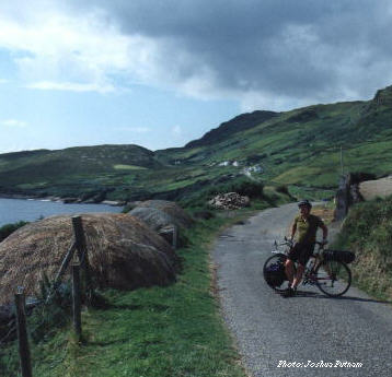
Our light breakfast led to an early lunch of fish and chips in Killeybegs. (Fresh fish and thick chunks of potatoes, hardly the same dish as most American fish and chips.) Passing Fintragh Bay we took the old coastal road around Muckross Head. Brian had developed a chest cold from the damp weather and nearly universal tobacco smoke indoors, so we stopped at a hole-in-the-wall chemist's shop in Kilcar for decongestant. After Kilcar we continued on the narrow coastal route as far as Carrick.
Puffy white clouds were all that remained of yesterday's rain, and the sun broke through to shine on the light chop on the water. It would have been a beautiful day for sailing. The old road is narrower and steeper than the modern highways -- on some hills I was wishing for a lower gear than my 28x30 granny gear. We left most houses behind, and passed miles of almost unpopulated countryside littered with stone walls and the fallen-in remains of stone houses. My mind wandered back to stories of the great flu early this century and the famine before it -- clearly this land used to support many more people than it does today.
Past Carrick and Slieve League the road climbed onto a barren highland of peat still turned by hand. I stopped to take pictures of an old man turning peat with a shovel, and felt the whole road sink beneath my feet when a truckload of air-dried turf passed by.
We arrived on the hill above Glencolumbkille just before dinnertime. Seen from above in the evening light the town seemed to have popped out of a fairly tale -- a single shaft of direct sunlight hit the spire of a church as we glided down the windy road into town. We bought stew and rice again, then headed up a steep, narrow side road to a hostel overlooking the reconstructed folk village.
The hostel's water ran brown with peat, and its gas stoves barely worked. I pulled out my camp stove and cooked beneath the trees, looking out over the thatched roofs of the village towards the sea. Having grown up in the dampness of Puget Sound, I was pleasantly surprised not to be surrounded by mosquitoes under dripping trees in August. After the rice and stew we opened a bottle of port and a package of chocolate-covered digestive biscuits.
During the night I awoke to the sound of heavy rain and wind shaking the tent and the trees above it, and I couldn't help going over in my mind what I had done with every piece of clothing and equipment: had I left anything out to get soaked? Was the stove put away? Were our bikes OK in the wind? Eventually I drifted back into a fitful sleep, waking again as dawn lit the tent.
The rain was still coming down in sheets as the day dawned, so Brian and I decided to stay in Glencolumbkille for the day. We had planned on bad weather, and allowed several days of slack in our schedule for just this sort of layover. We finished our digestive biscuits for breakfast, then decided to visit the famous folk village below us.
Although the folk village was just a stone's throw away down the bluff, by road it was a couple of miles, back through town and along the shoreline road. Perhaps the village was run down and tired after a full summer of tourism, but it seemed very overrated. The thatched cottages representing various centuries were full of European tourists and devoid of Irish staff, but the village gift shop had an excellent selection of Irish whisky marmalade and chocolates. [I hope I don't go on too much about food and drink, but such simple pleasures are crucial to a good bicycle tour.]
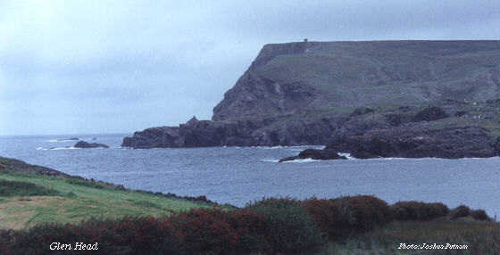
We left the folk village and headed back towards Glencolumbkille town. The beach was empty apart from a few local children, and we were at a loss for what to do until we spotted the gravel road climbing up Glen Head. Our hostel was on the south side of the bay, while Glen Head was on the north. At the top of the track we could see an old stone tower overlooking the sea. According to a storekeeper, this tower had seen part of the pathetic remains of the Spanish Armada breaking up on the rugged Irish shoreline. True or not this added to the allure of the tower rising over the desolate point, and we started up the road.
At first the road was easy, not too steep and at least partially paved. We crossed a small stream as dark as Guinness, carrying the runoff from the peat surrounding the town. After the last house we found the uphill turnoff, and soon the road became a rough track of gravel with large rocks that had apparently rolled down the steep slope onto the road. Switchbacks took us up the side of the point, the road getting a little narrower after each turn.
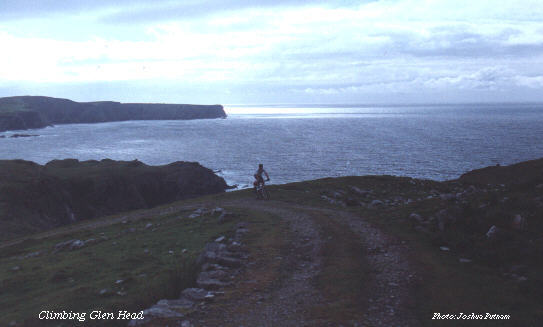
At the top of the slope we followed the road a short distance into the peat before realizing we were headed away from the tower. We turned back and looked for a turnoff to the tower, finding just a footpath headed north along the top of the bluff. This was rideable for a short distance, but soon I had to get off my touring bike and walk, and Brian hopped off his mountain bike a little later when we crossed a small creek. A few minutes' walking brought us to the tower.
The tower's wooden interior had collapsed long ago, so there was no point trying to reach the second floor entrance. Peering through first-floor windows revealed a mess of weeds and fallen stones. How long had this tower been untended? Some mortar was clearly newer than the rest, but all of it looked ancient. It was little more than a century ago that my great grandparents' wagons entered the Washington Territory, at a time this tower had probably been abandoned for generations. I was reminded of my culture shock when living in India as a high school exchange student -- what I thought of as ancient history was like yesterday to the people I lived with, and anything only a hundred years old was almost new. We Americans are truly children in some ways, both benefiting and suffering from the rootlessness of our society.
After walking around the tower a few times we walked to the edge of the bluff. At this point it had been fenced off, but the fence obviously could not hold the weight of a person -- perhaps it keeps local sheep from falling into the roiling sea below? The feeling was strangely similar to home, looking over the Pacific Ocean on the Olympic Peninsula. But behind me, instead of impenetrable evergreen rain forests, was a stone tower on a barren field.
Just then we noticed the leaden clouds above us lowering. By the time we made it back to the tower and our bicycles the wind had picked up enough that my panniers were pulling hard against the racks, and it was difficult to walk as we made our way back to the gravel road. Once we made it back down the road a ways we were sheltered from the worst of the wind, but the rain followed us down the hill.
We got back into the town early in the afternoon, and decided to stop in a pub for food and a couple of pints. Out the window we saw the rain come and go as the sun dropped in the west. Towards four o'clock we decide it was time to go, and headed to a sweater shop down the road looking for gifts. It's impossible to go to Ireland without someone asking for a sweater, a cap, or some other wool, but how do you carry such bulky gifts on a bicycle? The shop offered to airmail the gifts home for a good price, making our decisions easier. [As it turned out months later, the shop lied when offering us airmail -- the sweaters and scarves came surface mail. If you want something sent by air, send it yourself!]
After shopping we stopped again at the store, buying bottled water as well as noodles, stew, beans, and more digestive biscuits. I bought a few postcards, but never got around to writing anything on them, let alone mailing them.
We made it back to the hostel with a couple of hours of daylight left. I cooked an early dinner and we sat on the hostel's stone walls listening to the news on the radio, wondering if the IRA would really declare a cease-fire in their war against British rule in Northern Ireland. Surrounded by such beauty it was hard to fathom the conflict so nearby.
The morning dawned crisp and dry, and we got an early start. We hoped to make it all the way to Bloody Foreland. (The foreland's gruesome-sounding name isn't really so morbid -- its exposed stones are reputed to turn blood red in the setting sun.)
From Glencolumbkille we made a long, slow climb on a sparsely traveled road. Even though the wind had been off the sea all the way up the coast, we faced a headwind while climbing away from the coast, too. Roadside hedges near houses provided welcome shelter from the wind as we worked our way inland. The road dropped down a bit then ran upstream along the north bank of the Glen River until it became a trickle and vanished.
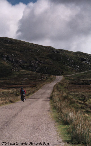
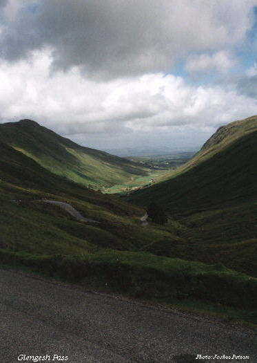
Without warning around a turn we were at the summit of Glengesh Pass, looking down the most scenic valley I have ever seen. Nothing in my rides over the Cascade Mountains or around the Olympic Peninsula could compare to this narrow valley and the steep, winding road down towards Ardara. It felt like finally seeing the promised land after wandering in the desert. All the way down the pass I was torn between the urge to descend as freely as possible and the desire to capture this incredible beauty on film. I settled for a few brief stops and snapshots down the road -- no picture can adequately encompass the incredible scenery. Perhaps it was the long, featureless climb or the change in the weather, but this moment still ranks as one of the best in all my years of cycling.
We stopped at Ardara Mills for more gift shopping, and once again the shop promised air shipping but delivered overpriced surface shipping. One package even arrived postage due! This sort of fraud is hardly unique to Ireland, but they pull it off much more sincerely than most.
We pushed on from Ardara through Glenties and Dungloe, enjoying easy riding away from the coast despite the rolling hills. Because we wanted to cover many miles yet and the main roads were not heavily traveled, we stayed mainly on the N-56 during the day. The road climbed again outside of Dungloe, passing Loch an Iuir before descending towards Crolly along the banks of a small river. Past Crolly we turned westwards on the T-72, and towards dinner we hit the town of Bunbeg, but decided to press on for Bloody Foreland. After Bunbeg the roadside became more crowded with holiday homes and some industrial development, interspersed with stunning views of the sun lowering over small islands off the coast. Just before sunset we finally reached Bloody Foreland, and stopped at a hillside restaurant/hotel to eat dinner and watch the sunset. For a reasonable price I had an excellent steak dinner and several relaxing pints of Guinness.
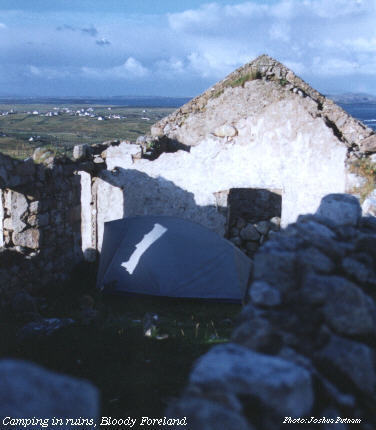
Asking the barkeeper at the hotel about possible camping sites, we were advised that any of the open fields near the hotel were free for camping, since nobody had any sheep in them this time of year. We rolled down the road a short distance and decided to camp inside the ruins of an old stone cottage, hoping its remaining walls would protect us from any winds or rains off the ocean. We pitched the tent by the last fading light of the evening, and got inside just in time for a light rain to start. I dozed off sipping port and thinking again of the vanished masses who once populated this coastline. The light rain turned to a drumbeat of rain and wind on the tent during the night, waking me several times before finally fading away a couple of hours before dawn.
In the morning we walked back to the road through a field littered, by daylight, with the signs of sheep from earlier in the year. We rolled back down the headland and backtracked towards Bunbeg. In Derrybeg we turned onto a side road that cut beneath the foot of Cronalaght mountain on the way to Gweedore. Jut east of Gweedore the road climbed above the banks of Lake Nacung, which glistened amid the green hills, with a backdrop of mountains in the distance. Just before we passed a power station that would ruin the view with wires I stopped to take pictures, greeting a few westbound cyclists as they passed.
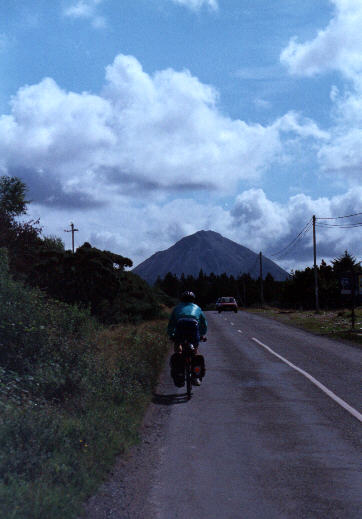
Before long the smaller L-82 sprouted to the right of the N-56, and we followed it eastwards beneath the flanks of the amazingly symmetrical Mt. Errigal. Along the way there was a strangely out-of-place church made of dark brick in a style unlike any building I had seen in Ireland -- almost Bavarian in appearance.
Just beneath Mt. Errigal there appeared a visitors' center, which was a rather modest affair but had good food at prices not too much higher than ordinary restaurants. While we were eating it rained briefly, but the weather had cleared before we left the gift shop.
The road climbed for a few more miles, then began a rolling descent towards Loch Beagh and Glenveigh National Park. Thanks to inaccurate road signs we missed the proper entrance to the park, and along with a confused couple in a rented car we rolled down a service road that entered the park grounds after the toll gate and public parking area. We rode on down the east bank of the lake, marveling at the landscaping and its natural backdrop. The beauty of the lake and the hills rising from it made me wish I had a canoe to set off for the inaccessible-looking far shore.
Glenveigh Castle rose out of the woods along the lake shore, looking a bit like something out of a story book. There was a long wait for a tour of the interior, so instead we toured the castle grounds on our own. The garden was an interesting affair, with salad vegetables interspersed among the flowers and shrubs. There were also sections of woods planted in the styles of various European countries, with calm walking trails meandering through the grounds. I could certainly see what had prompted the McIlhenies to buy the castle after making their fortune in the New World!
Leaving Glenveigh we entered a rolling range of foothills, finally nearing Letterkenny late in the afternoon. A quick glance at the survey map shows Letterkenny to be in a valley below the surrounding hills, but a closer look, which I hadn't taken, will show that the L-74 drops below the town and climbs for the last mile or so up a long grade. The map does not show a cold, damp headwind, either. Exhausted, shortly before reaching the town we pulled off and devoured an entire package of chocolate wagon wheel cookies, then rolled into town on the sugar rush. A hostel sign on the main road promised us relief from the saddle, and we were happy to find a room vacant. Not the nicest hostel, but clean and quiet and not too far from town center.
Then there was the problem of food: nothing near the hostel was open. The laundromat across the street explained that there was no water pressure, so we wandered towards the center of town down an exceptionally long, straight main street, finally deciding on a pizza place that smelled good from the road. We had the bad luck to be seated behind a very loud, fast-talking Italian woman who constantly gesticulated wildly with her hands while complaining about the service: her pizza was late, and too large, and the toppings weren't right, and the waiter let her wine get empty. She gave me a headache, but the food was good and the wine better, and in half an hour the endless grind up hill into town seemed impossibly distant.
When we got out the door the next morning it seemed the town had shut down entirely. Not only were the stores closed, but even the restaurants that usually served breakfast were shuttered. Not even a simple bakery was open, so after a breakfast of digestive biscuits and instant coffee we prepared to ride out into the countryside, hoping to find better hospitality in more rural areas. Near the edge of town we smelled food and turned into a corner store that had a small deli section where we gladly paid far too much money for pasta salad and hot sandwiches in plastic dishes.
After our long climb into town it was disheartening to see that the road to Balleybofey went steeply upwards as we left town -- obviously we had taken Letterkenny the wrong way 'round. Near the crest of the hill out of town we watched a happy collie chase a car up the grade in the slow lane, barking excitedly as the driver pulled away from him at the summit. Then he turned around and did it again for the next car, and the next. Our bicycles didn't excite his interest, however, and he let us pass unescorted. Perhaps were were a little too slow to be worth chasing.
The ride through Balleybofey was uneventful and easy. For once we had a constant, mild tail wind and no trace of rain. The landscape was uniformly green without any particularly spectacular sights, making this the longest stretch I rode without taking any pictures all month. At Balleybofey our route joined the N15 as we climbed towards the Barnesmore Gap. This was the closest our ride took us to the border with the North, and peering through my binoculars I could feel eyes looking back from the British observation station overlooking the Gap from, incongruously, the south side of the road. Occasional helicopters looped out over the road, too, reminding us again of the tension gripping this seemingly tranquil land.
At the summit of the Gap our tail wind turned into a head wind, but the road dropped before us into more rolling hills before reaching Donegal Town in the early afternoon. We had many miles to go yet, and since we had already seen the town center when we came from Sligo, we went to a bakery then sat on the stone wall around the fountain in the middle of the town square to enjoy several cream puffs and a quart of Lucozade each.
As soon as we turned south out of Donegal the sky began to turn cloudy, but for the time at least the rain held off. Between the sugary Lucozade and the cool weather I felt fresher than I had hours earlier climbing the Gap, and we made good time southbound along the N15, sticking to the highway for speed.
Out of Ballyshannon the road became more crowded with cars and tour buses, and we arrived in Bundoran to find some sort of festival in town, complete with throngs of pedestrians and crawling traffic. Scooting between a traffic jam and the sidewalk, I brushed a traffic cone, then Brian hit it with his left front pannier and went down noisily but without injury. His ego, though, was bruised by the laughter of a teenage girl hanging out in the doorway of a pub nearby -- unlike her friends she laughed when he crashed, not when he picked himself up. She definitely was not a Bord Failte agent! Brian gave her a quick lesson in American slang before getting back on his bike, straightening the bars and mirror, and riding a little more slowly down the road towards Ben Bulben, which once again dominated the landscape.
We passed under the tip of Ben Bulben as the evening sun lit it up under the clouds, brilliant green and glowing stone under a lowering sky. Just before the final descent to the Sligo waterfront we stopped for energy: more Lucozade and wagon wheel cookies.
I was feeling strong and fresh despite riding most of the day, and Brian agreed we would be better off passing through Sligo and camping somewhere south of the town, along the road to Galway. The problem was, whenever we felt tired our surroundings looked inhospitable for camping, and when we were in pleasant areas riding felt too good to stop just yet. The sun set before we were ready, and our dim headlights and tail lights were hardly adequate for spotting a good camp site. We decided to ask around in the next small town we came to, but it seemed a long way between towns.
The roadside south of Collooney hosted frequent encampments of Travelers, if you're polite, or Tinkers, if you're not -- Ireland's equivalent to Gypsies, reportedly descended from the homeless refugees of the Famine. Popular tales say that these wandering people can pick your pocket without getting close enough to shake hands, and so on. Off hand the stories sounded like bigoted fantasy, but riding along in the dark listening to their raucous parties and smelling the lack of plumbing in their encampments it didn't seem like a prudent time to seek the truth for ourselves, and we continued pedaling into the gathering dark.
Riding along the N17 at night was nothing like riding at night at home, even on my relatively rural island home. The night is never so dark at home, except perhaps when a winter storm kills the street lights in Seattle and Tacoma and returns our houses to gas lanterns and candles. Even the Travelers' camps were mostly lit by campfires and flashlights, though one or two seemed to have generators running. The road was smoother than most American pavement, too, having been paved that summer, and we seemed almost to float through the rolling countryside.
At last we came to a small town with an open gas station and several pubs. I went into the gas station for candy bars while Brian asked the girl behind the counter about likely camping spots or hostels. She was tired and sullen, answering in monosyllables with no suggestions. An older woman knew of just one B&B in town, a block or so down the road, but it had only one bedroom and she didn't know if it was taken. Hoping for the best we set off into the darkness again, then found the house and knocked on the door.
Luck was with us in spades! Not only was there a bedroom available, but the man of the house was late getting back from a football match in Dublin and his dinner was ready for us. We ate with the family then went into the living room where they showed us sing-along videos combining Irish folk songs with tourist footage of popular destinations until finally we were too tired to keep our eyes open.
It was my first night in a real bed since leaving Dublin for Sligo, and I slept as if dead, noticing nothing of the rain storm that blew in overnight.
A delicious breakfast made it even more tempting to stay another day rather than set off into the rainy headwind, but in the end we packed our dried clothes into our panniers and took water bottles full of sweet spring water with us as we set out towards Galway. What followed is to this day the most miserable bicycle touring misadventure I've ever had.
The night rain had turned into a light drizzle, but the wind was still strong from the southwest. The topo maps insist we were going down hill much of the day, but I can't remember ever being able to coast. I was out of cash and so was Brian, but Ballynacarrow was too small to have an ATM that would accept my cards, so in each town we passed I kept my eyes open for larger banks. I can't remember much else of most of the day. It wasn't raining while we passed through Tobercurry, I think, but it started again by Curry and was heavy before Charlestown. There was a long letup in the rain from somewhere north of Knock to somewhere south of Claremorris, but the rain stayed damp and cold. My left knee started to hurt a little, and I could feel the tight spot coming back where I had ripped my right Achilles tendon on a cold day in the North Cascades a year earlier. Brian has never liked the rain or cold as much as I do, and had an even more miserable time than I did. We began to talk about stopping at a hostel or even paying for a hotel.
The real weather hit somewhere after Claregalway. Clouds as dark as night blotted out the day's thin gray light then let loose a rain much stronger than a typical Irish shower head, and the wind got even stronger. Soon water was pooling along the road side, overflowing the gutters and running down driveways. Somewhere in one wide puddle my rear wheel found a deep crack my front tire had missed, and with a clanging noise the tent shifted off the rear rack. I put it back in place and rode on, grimacing in the gritty spray off passing cars. A twang followed by a crunch announced a broken spoke flopping into my rear derailleur. My fingers were too cold to do a good job truing the wheel, but I at least got the broken spoke wrapped around another one and got the chain running smoothly again.
We pressed on up hill into the rain. My rear wheel went out of true again, and I stripped a nipple trying to fix it with nearly numb hands. I let off the rear brakes and kept riding until the wheel was so out of true I was worried about it failing. I got off to look at it and as I bent down a passing truck threw a solid wall of water over me, feeling like a cold bath. I stopped.
Standing miserably in the rain I waved down a passing truck and asked for a lift into town. The driver apologized profusely but said he couldn't take us because the rain had delayed him too long and he hadn't been able to unload his cargo that afternoon. He reassured us that we were less than a mile from town center, however, so I got back on the bike for the up slopes and walked it on the down slopes, not trusting one soggy front brake to control my wobbling bike under a full load.
The N17 was flooded and we detoured around it within sight of the taller buildings of city center after a sodden woman laughingly warned us to "mind the puddle." The "puddle" was two blocks wide.
When at last we reached city center the sewers were erupting in the streets, welling up through drains and manholes like turgid brown fountains. I watched the bikes while Brian looked for a room somewhere, anywhere. I would gladly have paid for a five-star hotel if one had been available, but the hotels were all full. A brand new hostel had rooms, though, so we went in there.
They had caged bike storage, in out of the rain, and the building was warm and dry. They even had in-house laundry facilities. The most thrilling discovery, however, was in the bathroom: truly hot showers with enough pressure to blast the grit out of my hair and make my cold hands sting in the spray. I was actually feeling slightly human by the time I got out of the bathroom. A cup of warm port followed by a trip to Super Mac's for garlic fries and burgers completed the transformation.
In the morning I started looking for a bike shop that could repair my wheel, since I had stupidly forgotten to bring a spare spoke and nipple. With all the bicycle tourists in Ireland this seemed like it should have been an easy task, but after the third shop told me they only had spokes for 26-inch mountain bike rims in stock I gave up and bought a whole wheel, a nice Sansin freewheel hub laced to a Mavic MA-2. After briefly considering shipping my old wheel home I decided its rim was too worn to bother saving, so I unlaced it and found myself with 35 spare spokes, 34 spare nipples, and a spare hub with a bit of flange damage.
Unfortunately, all this took far too long to leave time for a trip out to the Aran Islands and back that day, so we instead toured the city and checked the train schedule for Dublin the next day.
We caught a morning train to Dublin, arriving early in the afternoon with plenty of daylight left to find our hostel near Stephens Green. I phoned home for the first time since Sligo, and checked in to see if anything critical had come up at work. I can't remember anything important enough to have disturbed my sleep after an early bedtime.
Unlocking and re-loading our bikes in the morning we set out vaguely southwards, asking directions repeatedly as we navigated the maze of Dublin and its suburbs. After one last stop at a gas station to get directions and top off my stove fuel, we followed a final residential street into the hills and began the climb towards Sally Gap, atop the Wicklow Mountains. The road climbed sharply out of the last neighborhood we passed, and soon a stunning view of Dublin opened out beneath us as we neared what a sign told us was Fox's Pub: the highest pub in Ireland. But it was too early in the day for a pub, so we ventured on into the flat, barren center of the mountains, a high plain of squishy land pierced by a single strip of asphalt without so much as a center line.
In the middle of this plain, with no other people in sight, a colorful dot on the landscape resolved itself into a lone cyclist headed the other direction. He sped by without a word, nodding silently over the whir of spokes in the breeze. Solitude returned. Until the next turnout, that is, where a businessman was stretched out in his car receiving the attentions of a bored-looking young woman. Neither of them said anything, either.
At the only real intersection on this leg of the ride we turned towards Laragh and Glendalough. A light drizzle blew in our faces as the gradual ascent turned into a gradual descent, then a steeper, winding drop alongside a stream that turned into a small river and plunged over a cliff in a spectacular waterfall. After the road dropped down to join the stream in its narrow green valley we came to the town of Laragh where we ate a late lunch and bought supplies for dinner. The day had turned sunny and calm, and rather than press ahead we decided to find a place to camp along side the Avonmore River. An old stone wall runs between the road and the river for many miles, and at one slightly broken-down section we spied a flat spot amid the trees. We put our bikes over the wall and followed them in, finding a perfect campsite with a short climb down to the river.
The river was beautiful and its noises relaxing, but as soon as the sun set a buzzing cloud of insects drove us into the tent.
Morning came with light rain that soon stopped, and we were on the road again before 9:00. We stopped to tour Avondale House, home of C.S. Parnell, but the tour was a bit disappointing, consisting mainly of a laundry list of which furnishings were original and where they had come from, with little historical context. Far more interesting was a sight later that day, a roofless church with an untended cemetery and trees growing up where the altar had been. With no guide to tell us the name of the place we could not find it in the tour books, but the gravestones suggested a wealthier past and many decades of neglect.
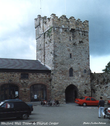
We continued on towards the coast at Arklow, then took the coastal roads along Kilmichael Point, through Castletown and Courtown and Killmuckridge, arriving at last in Wexford in the afternoon. Crossing the bridge into Wexford was somewhat intimidating with the heavy traffic, but once across we turned onto the waterfront, out of the heavy traffic and into a touristy district. The working waterfront seems to have been mostly replaced with restaurants and shops, including a good pizza shop.
New development surrounded ancient history throughout the town: a tourist center built in the old city walls; busy streets along side roofless ruins. There were so many historic buildings, not all of them had been turned into tourist traps, and we wandered through vacant church yards and fragments of walls. Having read the history of Wexford and grown up with the American habit of memorializing every significant event, I tried to find the town's old bull ring, where Cromwell massacred 3/4 of the population of the town after it fell to his army. I never found even a plaque for that, but there was a memorial to the Fenian rising of 1798.
Early in the afternoon we got back on the bikes and headed for Waterford. It was late enough in the day I doubted we would make it all the way to Waterford, but expected we would find some good hostel in such a touristy area.
The land was much flatter than what we had been riding in so far, nothing like the Wicklows or the hills of Donegal. We made mile after mile through rolling fields. The area lacks the drama of the hill country but feels very peaceful -- I could ride for miles without really thinking about much. Then Brian had a flat and thought his bike didn't feel right after he fixed it. I tried it out and he was right, but it had nothing to do with the flat -- his seat post had gradually slipped down without his noticing it until it almost fit my 31" inseam, not his 34" legs. With that fixed we hit the road again.
On our left there appeared a complex of ancient looking buildings in a state of obvious disrepair, but nothing in my tour book identified the site. Riding down the gravel road we came to a sign identifying Tintern Abbey, a name that brought back memories of my father's old sailing books and tales. In the 12th Century an English nobleman was caught in a storm with is family. The loss of the de-masted ship appeared certain when the man knelt on deck with his family and prayed for deliverance. The ship blew past the perilous reefs of the Hook Peninsula and landed at the head of a sheltered bay, where the man founded the Abbey in gratitude. Although the site was mostly closed for renovations, no work was being done this late in the day and we took our time browsing the ruins.
By the time we got back on the road the sun was nearing the horizon and it was time to look for a campsite or hostel. Up ahead we knew Waterford Harbor separated us from Waterford town, so we inquired at a small town pub and were invited to pitch the tent in a field behind the pub. As the sun set I tipped back a pint of Murphy's and tried to make conversation, but we had arrived on some special occasion and the locals, although as accomodating as ever in Ireland, were wrapped up in local affairs. Pub food and another pint made way to an early bedtime.
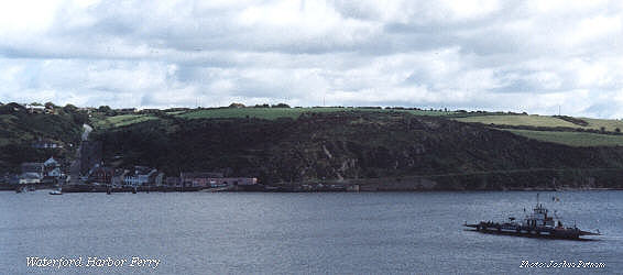
A few miles past the bakery we started coasting down towards Waterford harbor. On the east side of the harbor the ferry landing is just below Balleyhack Castle, which doesn't look much like a castle but seems to earn a steady income from tourists waiting for the ferry. The Castle has mannequins showing the lives of the 14th Century Knights Templar who built it.
The ferry across the harbor was a simple landing craft holding just a handful of vehicles. Our bikes were joined in line by a pair of German tourists on rented mountain bikes. Near the landing a small moorage held several old wooden fishing boats and a single sailing yacht. The far shore showed no signs of a major town.
As we drew near the west side of the bay we could see a road climbing up from the waterfront. This turned out to be the highway to Waterford, and after waiting for a few cars to go by we started riding up the hill, stopping half way up to look back across the bay through a gap in the hedges.
At the top of the hill we found a green, pastoral route through fields and trees -- it seemed Waterford was a bit farther than we had been told on the far side of the bay. It was nearly lunch time before we approached Waterford, so we stopped at a roadside pub and restaurant whose grounds featured an old lime kiln and ice house.
Waterford, like Wexford, was filled with old churches and historical ruins, but seemed to have more of a life outside tourism. Waterford Crystal is well known, but not a practical gift to carry home when cycling, so we let that souvenir opportunity pass and after touring the waterfront and the historic sites we got back on the road, enjoying bright sunshine and only spotty clouds as we turned northwesterly along the placid river banks.
Our next goal was Cashel, but that was too far for a comfortable ride that night, so we pulled out the tour guides and settled on Clonmel. The name had a fainly familiar ring to it, but I couldn't remember why. We rolled past fortified houses, small cottages, and a splendid private estate turned B&B before climbing a ridge over the river.
The sun began to set as we were in the woods on this ridge, and as we left the far side of the ridge there were lights and noises in the distance reminiscent of a circus. As we got closer and closer we found both the source of the noise and the reason the name Clonmel was familiar: by chance we had decided to camp in the town hosing the Fleadh Ceole, Ireland's great musical festival. All ordinary camp sites were taken, of course, and we rode through bustling streets listening to live bands while trying to figure what to do. Luckily the local football club had decided to rent camping space on their field and we gratefully paid for a spot.
While I pitched the tent and thought about sleep, Brian headed out for a night on the town. Personally, I was exhausted, but Brian seemed to have found a second wind somewhere along the road from Waterford. It was certainly a change from Donegal.
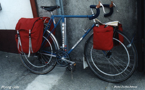
It turned out we had arrived on the last day of the Fleadh, so in the morning we joined thousands of people leaving Clonmel. Downtown we came across another cyclist headed for Cashel, an Englishman riding a strange looking bike with the ungainly title of the "Flying Gate." It had no standard seat tube, but rather a vertical tube rising to the top tube, with a stub of seat tube cantilevered behind the vertical tube.
Just out of Clonmel we came to a road block on our intended route, but instead of a detour we found an unexpected boon: the highway was closed for repaving, but the police decided the closure did not apply to bicycles, so we had a private highway with perfect pavement almost all the way from Clonmel to Cashel.
The Rock of Cashel rises from the surrounding fields like a dream, spires and roofs crowded atop a high hill, surrounded by walls and massive Celtic cross grave stones. It was past lunch time and we had not eaten, so sitting on a stone wall beneath the Rock I cooked spaghetti, only to discover I had mis-packed the forks. Boiled tent pegs made acceptable chopsticks. Then it was time to find a place to camp.
On the side of the hill away from town, surrounded by stone walls and green fields, just below the Rock itself, we found a perfectly situated hostel, complete with warm, moderately strong showers. I set up my camera on a tripod to take a series of shots of the Rock while the sun set behind the hostel. The stone walls and green hillside reflected the colors of the setting sun through the clouds, changing dramatically from minute to minute as the angles and filtering changed. A few cud-chewing cows wandered through the frames, appearing as ghostly moving images in the slow exposures. As the last light faded we hiked across the base of the hill into town, getting a burger before finding a good pub.
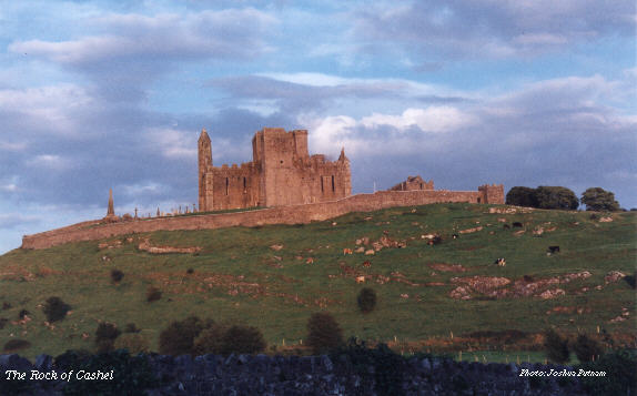
In the morning it was time to see the Rock. We rode the long way around to town and left our bikes locked at the gateway to the top of the Rock. The churches and graves atop the hill were crowded together but spanned hundreds of years, from a simple round tower to the ruins of an immense Gothic cathedral. Outside the view from the Rock was spectacular, miles and miles of rolling green hills fading off in the hazy sunshine.
After seeing the rock it was time to ride again, this time towards Limerick.
[That's as far as I've written. The rest of the trip was fairly uneventful except for the flight home, which was many hours late and landed at Boston instead of New York, then sat on the runway for hours before finally flying to New York. I'll never fly ATA again!]
This page written by Joshua Putnam. Please feel free to email questions, comments, corrections, suggestions, etc.
© Joshua Putnam