If you like hills and mountains, this road is for you. Starting on the shores of Puget Sound it climbs over three mountain ranges in under four hundred miles before dropping back to the banks of the Columbia River by the Washington/Idaho border.
Since I've ridden this route many times, this isn't a writeup of a single ride, but rather a general guide to the route.
I first rode this route in the Great ESCAPE, a charity ride sponsored by Associated Grocers. With nearly 100 riders the Great ESCAPE (Evergreen State Cascade and Plains Experience) was much larger than the average touring group, so its route and accomodations aren't always exactly what would be best for a solo or small group tour. Most of this writeup follows the Great ESCAPE route, but I will add notes on places the ride did not stop that I prefer when traveling by myself.
Bayview State Park is right on the shore between Anacortes and Burlington. It isn't actually on Highway 20, the North Cascades Highway, but is near the highway and makes a good jumping off point. In the lowlands around Puget Sound, SR20 has heavier traffic and narrower lanes than most cyclists would prefer, so rather than heading straight for the highway, take Wilson Road, a much less travelled two-lane highway that largely parallels SR20 as far as the town of Burlington. Burlington is on the East side of Interstate 5, and even that short distance noticeably reduces traffic on SR20.
The area between the shoreline and I-5 was once all rich farmland, and much of it still is, but urban growth is rapidly claiming small farms, replacing them with malls and homes. There's still enough farming to catch a strong whiff of manure in the spring and see beautiful flowers in the summer and fall. Past I-5 traditional land use slowly changes from farming to forestry. What forests stand in the lowlands are mostly regrowth after past logging.
Beyond Burlington SR20 is still busy, especially in summer when tourists and locals alike flock to the forests and lakes of the North Cascades. There are also growing numbers of commuters using the highway at rush hour. Civilization begins to fade away as the highway now tracks the Skagit River closely, cutting through the foothills of the Cascades, avoiding the steeper slopes on either side. The highway passes through the town of Concrete, below Baker Dam at the base of Lake Shannon, through the small town of Marblemount, and climbs along the river to Newhalem. Newhalem is a small town owned by Seattle City Light, just below two of the utility's early hydroelectric dams. The town has one general store, well stocked but overpriced, and a pleasant nature walk along the banks of the river. In teh center of town an old steam locomotive sits on the same stretch of lawn used as camping space by the Great ESCAPE.
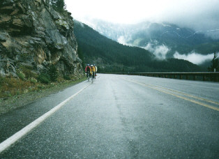
When traveling by myself, however, I much prefer the camping further up the highway. Just past Newhalem the real mountain highwy begins, with a bridge passing over a beautiful waterfall just outside of town. Cllimbing further the highway overlooks Gorge Dam and the long, narrow Gorge Lake, then Diablo Dam and Diablo Lake. These two lakes, fed by cold moutnain runoff, stay cold and blue all summer. At the southern end of Diablo Lake there is a small campground at Colonial Creek. This is a much nicer place to stop for the night or to spend a few days than Newhalem, with direct access to the lake shore and many good trails for walking in the woods. But watch out for bears in the outlying camp sites: some clueless city people seem to think feeding the bears is fun, so they know that campers are a likely source of good food.
Above Diablo the highwy climbs around the flanks of Ruby Mountain, passing
the south end of Ross Lake, then climbing with Ruby Creek and Granite Creek
towards the crestline of the Cascade Range.Ā
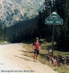
The first crest is reached at aptly named Rainy Pass, 4855 feet. This whole area can be miserably wet and cold even in the middle of summer if a wet front is blowing in off the Pacific, but at other times temperatures on the climb to the pass exceed 90 degrees. Pack rain gear and plenty of water.
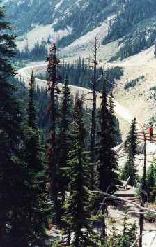
Leaving Rainy Pass the highway drops quickly, then starts climbing again towards Washington Pass, 5477 feet, the second pass of the Cascade Range. It's a bit steeper in places than Rainy Pass, but neither is steep enough to stop a well-geared touring bike. At the summit of Washington Pass, be sure to stop and walk out to the scenic overlook for scenic views of the highway dropping away below and the snowy slopes of the surrounding mountains.
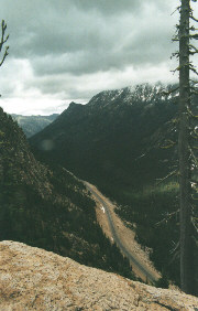
When leaving, beware of gravel on the steep sweeping curve below the pass. It's easy to exceed 50mph on an unloaded bike below the pass, and uphill traffic sometimes passes slow trucks in the oncoming lane despite the double yellow line. Have fun, but stay in control.
The route descends past the Early Winters campground and into the Methow Valley. The climate of Eastern Washington is much dryer than the Western slopes of the Cascades, and yesterday's forests of fir are replaced with sparse trees and rolling hills. Thirty miles past Washington Pass the highway rolls through the small town of Winthrop, an old-West tourist trap with excellent fudge and ice cream. The ESCAPE stops in the town's middle school lawn, but there is also a private campground in town, and some opportunities for camping in the rough outside of town.
Southeast of Winthrop the ESCAPE swings off of SR20 onto scenic back roads
for nine or ten miles, though SR20 is also a pleasant ride through this
area. The back roads rejoin the main highwar around Twisp, where the highway
begins to turm more easterly again. Rolling through the bottom of the Methow
Valley the route begins climbing again into the Okanogan Forest. This dry,
hilly forest is much different from Washington's western forests, with
trees growing much slower in the dryer climate. In the middle of this dry
forest the highway climbs over Loup Loup Summit, 4020 feet.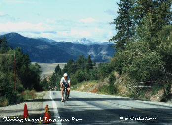 This
is a very gradual pass, not like the steep slopes of the North Cascades,
and it lacks the snowy peaks and sweeping views of the Cascade range, but
has a more subdued beauty of its own.
This
is a very gradual pass, not like the steep slopes of the North Cascades,
and it lacks the snowy peaks and sweeping views of the Cascade range, but
has a more subdued beauty of its own.
The highway descends gradually into the Okanogan River valley, running into the riverside towns of Okanogan and Omak. You have a choice of following the highway across the river in Okanogan or following side roads through Okanogan to Omak, with a second bridge across the river. Omak is famous, or infamous, for its Suicide Race, a horse race that ends with a dangerously steep river crossing.
The Great ESCAPE stops in Omak for the night in the soccer field of the city park. In summer the river flowing between the park and the fairgrounds is cool but warm enough for swimming, especially if the weather is hot.
Out of Omak the highway turns north, joining Federal Highway 97 along the Okanogan River as far as the town of Tonasket. The route climbs some low rolling hills along the west bank of the river, following an old wagon road. The highway mile posts along this stretch of the route are those of Highway 97, not SR20, so don't let them fool you.
Around six miles south of the town of Tonasket, the road crosses over the Okanogan and runs closer to the river along the east bank. Just after entering Tonasket, SR20 branches right off of Highway 97. If you want to head into town, stay on 97 for a few more blocks. Tonaskt is the last singnificant town for many hours, so it's a good place to stock up on snacks and check your water supply in warm weather.
SR20 turns almost due east out of Tonasket and begins a gradual climb from around 1200 feet towards Wauconda Summit, about 20 miles down the road at 4310 feet. This can be one of the hottest parts of the ride in hot weather, and the terrain shows the dry climate. None of the climb is particularly steep, but there is little mid-day shade before entering the Okanogan National Forest.
The east side of the summit is not much steeper than the west, and the road maintains a moderate down grade most of the way to the old town of Republic, one of the oldest towns in the state of Washington. The ESCAPE stops for the night at the Ferry County fairgrounds, but if you want to put in a few more miles, follow the SR21 northbound to Curlew Lake.
From around 1500 feet in Republic SR20 runs a few miles with SR21 before beginning the climb over Sherman Pass. Sherman Pass is the highest on the route at 5575 feet. It sits about 15 miles past Republic in the Colville National Forest, atop the Kettle Range. Before reaching the pass you will run through the remains of a forest fire several years ago, with new growth pushing up amid the blackened trunks of the old forest.
The east side of Sherman Pass presents a rare treat, 22 miles of almost continuous descent to the Columbia River. The initial descent is fast and curving, followed by a meandering drop through the forest along Canyon Creek, giving back all the elevation of the climb out of Republic and then some. The road turns north for a few miles along the west shore of the huge Franklin D. Roosevelt Lake formed by Coulee Dam. Soon you reach the junction of SR20 and Highway 395, and turn right across the bridge over the river.
SR20 and Highway 395 rise past the small town of Kettle Falls and into the larger town of Colville. 395 turns south but we continue east on SR20, climbing again into the Colville National Forest. Look for the signs for Ione and Newport. Less than 30 miles from Colville the highway passes along Lake Sherry and then Lake Gillette. Lake Gillette has numerous camp sites and a small general store catering mostly to people fishing on the lake.
Leaving Gillette Lake the highway passes Lake Thomas, Lake Leo, and several smaller lakes, then drops to the bank of the Pend Oreille River by the crossroads town of Tiger. SR20 heads south along the west bank of the river, but if you turn north towards Ione and cross the river there you will find the much less travelled LeClerc Creek Road on the east bank of the river. Either route is mostly flat and follows the river as far as Newport. SR20 runs straight into Newport from the Washington side, while LeClerc joins Federal Highway 2 in Oregon. Highway 2 is much busier than SR20, but you only need to take a quick right rurn and cross a bridge over the pend Oreille to find yourself in downtown Newport. Newport is a large enough town to have real pizza, good shopping, etc.
Each time I reach Newport I want to keep heading east, but so far I've never had the time. One day I may get back on Highway 2 and see how I like touring in Idaho and Montana. I've been through there driving, but never on a bike.
This page written by Joshua Putnam. Please feel free to email questions, comments, corrections, suggestions, etc.
© Joshua Putnam