Overview
This review is an update to my TopoUSA 3.0 review. I'm mostly going to describe what has changed, you should refer to the original review for more examples of what this software can do.
What is new?
Map editing
TopoUSA 4.0 allows you to add new roads, trails, or paths to maps. These become routeable so that they can be used on route sheets. It doesn't allow you to remove roads which incorrectly appear on the map however, so you can't fix all map errors.
A workaround that allows you to remove incorrect roads is to mark them as "No Way" using the Edit Roads. feature of the Route tab. This will still draw them on the map, but they won't be routable.
Map editting is the best new feature of TopoUSA 4.0 because it allows you to correct mistakes in their maps and also allows cyclists to add bicycle trails to maps.
Split Screen
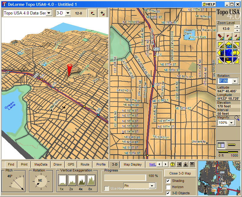 You can split the screen to show 2D and 3D maps at the same time.
As you scroll the 2D map the 3D map updates too. 3D mapping doesn't
seem to be any faster than it was in TopoUSA 3.0 however, so I don't
think that this feature is as useful as it could be. If you are
generating a 3D map for printing this will help you get the perfect 3D
map. On my computer (Athlon 1.2ghz, 1024mb of memory, but no 3D
accelerator card) it takes about 5-8 seconds to redraw the 3D map
after scrolling the 2D map depending on how complex the map is.
You can split the screen to show 2D and 3D maps at the same time.
As you scroll the 2D map the 3D map updates too. 3D mapping doesn't
seem to be any faster than it was in TopoUSA 3.0 however, so I don't
think that this feature is as useful as it could be. If you are
generating a 3D map for printing this will help you get the perfect 3D
map. On my computer (Athlon 1.2ghz, 1024mb of memory, but no 3D
accelerator card) it takes about 5-8 seconds to redraw the 3D map
after scrolling the 2D map depending on how complex the map is.
The split screen map also lets you show two 2D maps at the same time. I think that this is a much more useful feature; you can use one to zoom in and check street names and use the other to get an overview of your route. A shadow cursor is shown on the second map so that you can see exactly where you are pointing.
Find
The Find feature works a lot better in the new version of TopoUSA. Previously you had to tell it what type of thing you were looking for, then describe the thing. For example if you wanted to search for "Seattle, WA" first you would have to "Search for>> Placename", then type "Seattle, WA". I found some of the search options to be confusing (for instance what is the difference between an "Object Name within a Region" and a "Feature Type within a Region"). In the new software you can just type the name of something and it will find it.
Map Data
The map data manager is integrated into TopoUSA now. You can switch between different map data sets without having to exit and restart the software.
Issues
User Interface
The user interface is better than TopoUSA 3.0, but it is still very different from most Windows applications and is often hard to navigate.
Routing Accuracy
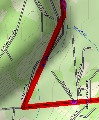 TopoUSA routes still don't correctly follow the roads if you have
waypoints which are more than about 10 miles apart. This results in
lower accuracy for route lengths and profile information. It is still
very easy to end up with maps that look like this one when you zoom in.
TopoUSA routes still don't correctly follow the roads if you have
waypoints which are more than about 10 miles apart. This results in
lower accuracy for route lengths and profile information. It is still
very easy to end up with maps that look like this one when you zoom in.
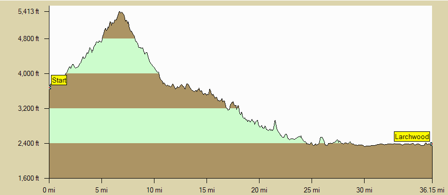
I talked to a Delorme customer service representative who told me that they considered this to be a drawing issue only. In response I made this animation which shows the profile display for a route. One frame of the animation is from a version of the route that has no vias, the other has three vias to make the route follow the road. You can see that the version with no vias incorrectly shows the route going up and down more hills than it really would, and also gets the route distance incorrect (it shortcut almost two miles over a 38 mile route).
Scrolling
 TopoUSA doesn't draw the map until you finish scrolling. While
you are scrolling the map it just shows a hash pattern for the area
that you are scrolling to. I find that this makes it harder to
browse the map. TopoUSA 3.0 didn't have this problem, it would
draw a simpler version of the map while scrolling, then fill in
shading and other features when you stopped. This picture shows a map
as it is being scrolled to the northwest.
TopoUSA doesn't draw the map until you finish scrolling. While
you are scrolling the map it just shows a hash pattern for the area
that you are scrolling to. I find that this makes it harder to
browse the map. TopoUSA 3.0 didn't have this problem, it would
draw a simpler version of the map while scrolling, then fill in
shading and other features when you stopped. This picture shows a map
as it is being scrolled to the northwest.
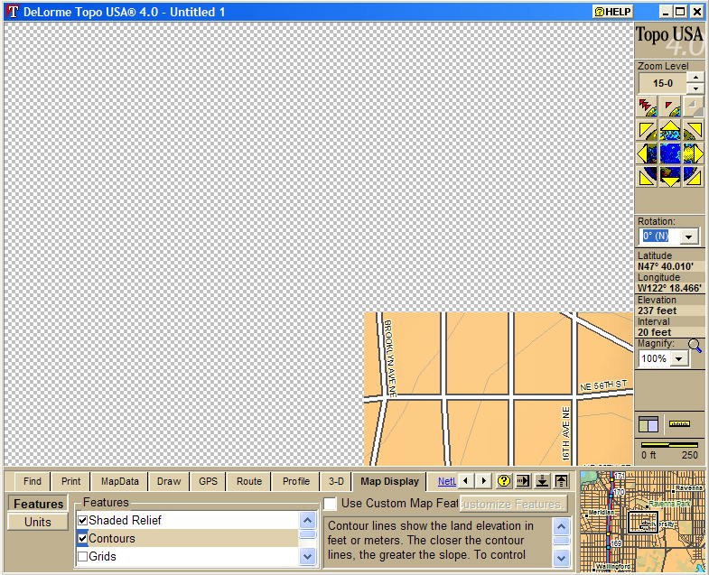
Display on monitors with large fonts
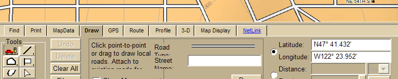 I didn't raise this issue in my TopoUSA 3.0 review, but both
versions of the software don't display correctly if you have the
Windows DPI setting set to "Large Size (120 DPI)". This is not a
display mode used by most people, but it is helpful to use it on some
most resolution monitors. The picture below shows what the Draw menu
looks like on my computer. I didn't crop the bottom of the dialog
box, it just isn't shown to me.
I didn't raise this issue in my TopoUSA 3.0 review, but both
versions of the software don't display correctly if you have the
Windows DPI setting set to "Large Size (120 DPI)". This is not a
display mode used by most people, but it is helpful to use it on some
most resolution monitors. The picture below shows what the Draw menu
looks like on my computer. I didn't crop the bottom of the dialog
box, it just isn't shown to me.
Delorme pointed out to me that this their readme file says that large fonts are unsupported with their products. This makes the product a lot less useful on modern laptops with high resolution displays where large fonts are sometimes essential to comfortably use other applications.
Map Errors
DeLorme claims to have corrected many mapping errors, but the ones that I remember from TopoUSA 3.0 are still in TopoUSA 4.0.
Mixed Routing
TopoUSA still doesn't allow you to make one route which contains segments which are both on roads and trails. This is annoying for planning cycling trips, where many trails are open to bicycles. You can work around this by creating new "roads" which overlay the trails that you want to route along.
Conclusion
TopoUSA 4.0 is a fairly minor upgrade from TopoUSA 3.0. If you already own TopoUSA 3.0 I wouldn't recommend purchasing the new version. I returned my copy because it still had the routing bug, and the other features weren't worth the $70 upgrade price that I was offered. If they fix the routing bug I'll buy a new copy. Despite it's many faults TopoUSA is still the best software that I've found for planning bicycle trips.