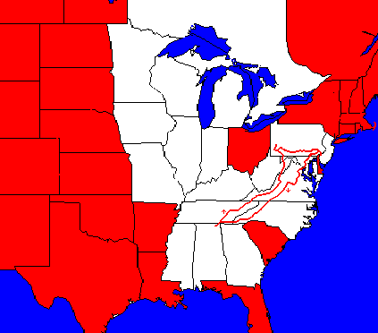
Journey to Pennsylvania, 1988
 This
was my first long trip in 17 years, although I made shorter bicycle camping
trips in 1974, 1986, and 1987. Probably for that reason, it was the most
exciting trip (and the most stressful trip) of all the ones I have taken.
At the time I took the trip, I could hardly afford to do so, since I had
earned less than $8,000 during the previous six months and had been unemployed
for a long time prior to that. However, in another sense, I could not afford
not to take the trip, as I needed a real psychological boost, which I always
get from my bike trips.
This
was my first long trip in 17 years, although I made shorter bicycle camping
trips in 1974, 1986, and 1987. Probably for that reason, it was the most
exciting trip (and the most stressful trip) of all the ones I have taken.
At the time I took the trip, I could hardly afford to do so, since I had
earned less than $8,000 during the previous six months and had been unemployed
for a long time prior to that. However, in another sense, I could not afford
not to take the trip, as I needed a real psychological boost, which I always
get from my bike trips.
A
note about the use of time rather than mph on this trip: My
cyclometer did not compute mph and also had to be manually started and
stopped. Since I often forgot to do so, I estimated the missing time at
the end of each day; therefore, a calculation of the miles per hour based
on these figures would be misleading.
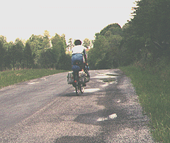
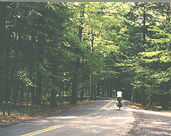
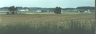
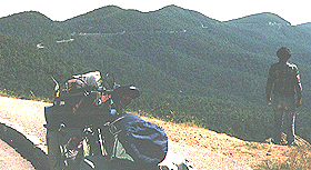
Day 1: When I stopped
by the store today, everyone saw my touring bags, and they asked me where
I was going. I really wanted to share my excitement, but since my cabin
in the woods had been burglarized more than once, I didn't want my departure
to be common knowledge, so I just told everyone I was going "across the
river." Didn't say how far across did I? My mostly flat route took me past
the base of wooded mountains, over a low pass, and across the Tennessee
River. I followed the river and the mountain north until they both turned
east, and then I turned north again at the first chance. While pedaling
down the road, I heard the sound of a truck gearing down, so I looked for
a wide spot, moved over, and signaled for him to pass. In Alabama, he would
have blasted me on his horn. I soon turned onto a lightly-traveled road
and much later found a place to camp that was down out of sight of the road along
a small creek.
Scottsboro - Dunlap, Tennessee, 75 miles, 5 1/3 hrs., May 3.
 Day
2: Today was a tough day for two reasons: rain and hills. The back
road I had chosen had many small, extremely steep hills, one right after
another. However, the main highway was crowded and the weather was rainy,
with several good downpours. When I stopped to dry my things in the laundromat,
a woman asked me how us bike travelers managed to get a shower. Speaking
as a veteran (my first out-of-state bicycle camping trip in 17 years), I said, "It's easy.
I've had three so far today." That night, I climbed up onto the plateau,
and camped in a very rocky, wooded spot. It's important, in placing the
tent, to carefully set it to sleep between the rocks, as removing rocks creates holes
that are more uncomfortable than the rocks. Day
2: Today was a tough day for two reasons: rain and hills. The back
road I had chosen had many small, extremely steep hills, one right after
another. However, the main highway was crowded and the weather was rainy,
with several good downpours. When I stopped to dry my things in the laundromat,
a woman asked me how us bike travelers managed to get a shower. Speaking
as a veteran (my first out-of-state bicycle camping trip in 17 years), I said, "It's easy.
I've had three so far today." That night, I climbed up onto the plateau,
and camped in a very rocky, wooded spot. It's important, in placing the
tent, to carefully set it to sleep between the rocks, as removing rocks creates holes
that are more uncomfortable than the rocks.
Dunlap - Crab Orchard, 64 miles, 5 hrs., May 4.
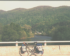
Day 3: Today, even though
more downhill than up, was rough on me, and I stopped after just four hours
of cycling. I guess I've been pushing too hard the last few days. Following
the Tennessee Bike Route, I descended down off of the Cumberland Plateau
at high speed with a tremendous view that I could barely take in. At the
bottom of the mountain, the route became hilly, and I was passed on a hill by a man
and woman on swift bikes, the latter looking back at me. I camped next
to the fence of the interstate at a site that other campers had used before.
Crab Orchard - Rockwood, 52 miles, 4 hrs., May 5.
Day 4: For a while, the traffic
just got worse as I neared and passed Knoxville. Then I was traveling along
a pleasant creek in a narrow valley for miles. When I reached Washburn in the afternoon, everyone
started waving at me, including: two women in different yards, one cutting
grass; an old man going to the mailbox and an old woman driving by in
her car; the police chief and deputy in their car; a coal truck driver
and a lumber trucker driver in their vehicles; and all the crew of a lumber
yard. It was an extra friendly wave too, a wave that said, "We're always
happy to welcome cyclists." Which is exactly what the store owner said
too. As darkness approached, I couldn't find a place to camp. Then I crossed
a narrow, wooded ridge. The sides were too steep, but at the top, there
was a hiking trail. So I camped on the trail as my only choice, feeling
a little guilty.
Rockwood - Stone Mountain, 81 miles, 6 1/6 hrs., May 6.
 Day
5: The roads were lightly traveled this morning as I cycled to Camelot,
a failed enterprise turned into overgrown ruins. While there, a couple
stopped their car and, as I described my trip to them, I noticed that her
eyes were shining -- a moment that has charmed me ever since. It's nice
to be a hero. I reached Kingsport over back roads, but then I ran into
traffic, so I asked a police officer if the alleyway continued on through.
He said to me, "You're in Tennessee, son. You can ride right down the main
streets if you want to." Although he misunderstood my intent, I appreciated
his attitude. That night the only camping spot I could find was on an abandoned
RR line just about a bend in the stream. Day
5: The roads were lightly traveled this morning as I cycled to Camelot,
a failed enterprise turned into overgrown ruins. While there, a couple
stopped their car and, as I described my trip to them, I noticed that her
eyes were shining -- a moment that has charmed me ever since. It's nice
to be a hero. I reached Kingsport over back roads, but then I ran into
traffic, so I asked a police officer if the alleyway continued on through.
He said to me, "You're in Tennessee, son. You can ride right down the main
streets if you want to." Although he misunderstood my intent, I appreciated
his attitude. That night the only camping spot I could find was on an abandoned
RR line just about a bend in the stream.
Stone Mountain - Mendota, Virginia, 60 miles, 4 1/2 hrs., May 7.
 Day
6: In the morning when I arose, three people were at the river fishing.
I very quietly packed my gear and then I pushed the bike down to the creek.
I thought I had been completely undetected until I noticed that only two
people were there; the third was on top of the RR embankment. This section
was very pretty, since I was following streams and had steep wooded hills
on either side. At Saltville, the store owner wanted my picture. At Ceres,
I found two Appalachian Trail backpackers to camp with in the shelter,
and they told me about their adventures and problems. Day
6: In the morning when I arose, three people were at the river fishing.
I very quietly packed my gear and then I pushed the bike down to the creek.
I thought I had been completely undetected until I noticed that only two
people were there; the third was on top of the RR embankment. This section
was very pretty, since I was following streams and had steep wooded hills
on either side. At Saltville, the store owner wanted my picture. At Ceres,
I found two Appalachian Trail backpackers to camp with in the shelter,
and they told me about their adventures and problems.
Mendota - Ceres, 66 miles, 5 hrs., May 8.
Day 7: For three hours, sipping
soft drink to boost my speed and with a good tailwind, I averaged 16 mph.
I hit very bad, high-speed truck traffic at Popular Hill. There was a great
view where I crossed the New River. In the late afternoon, I kept climbing
and climbing, with only farm land around. Towards evening, I knew I had
to camp somewhere, and a family out walking suggested that I try the churchyard.
Ceres - Sinking Creek, 79 miles, 5 1/3 hrs., May 9.
Day 8: In the morning, I
reached a 2,700 ft. marker. When I stopped for pictures on the descent
to Newcastle, I met some cyclists and their families with their bikes on
their car roofs. I told them that I had been frustrated by the hills. They
told me that they had come the way I would be traveling, and I would find
the rest of the way flat and smooth. Following their careful directions,
I found myself climbing once again until I reached 2,400 ft.! However,
another motorist I asked along the way also told me that this route was
flat with just one hill! Never trust a motorist about hills! Never consider
someone with the bike on the roof a cyclist! That evening I rode into Clifton
Forge, a railroad town, and camped near the park beyond.
Sinking Creek - Clifton Forge, 57 miles, 4 hrs. + 1 hr. walking,
May 10.
 Day
9: In the morning, I crossed the highest climb yet. On the way up,
I fortunately found a store to rest in and get something to eat. The manager
treated me nonchalantly as if cyclists came by every day, which surprised
me. So, when I left, I said, "Well, I better get up this hill." I heard
him turn and say to someone else, "Hill! He calls this a hill!" Well, I
got over it without any trouble, but a little walking, and every climb
has been a hill ever since. As soon as I was over the top, it was a steep
road down, and then a long slow grind up to Monterey, over half a mile
high again. No trees had turned green yet, and I was told the snow melted
just two weeks earlier. Past Monterey, I started looking for a place to
camp, but I was near a tourist area, and "No trespassing" signs were everywhere.
Finally, I noticed a ledge above the road that I thought would make a great
spot, and by good luck, a side road climbed up to it. So by pushing my
bike a little ways, I had a great camping spot. However, in fighting a
fallen tree branch, I managed to break a spoke. Day
9: In the morning, I crossed the highest climb yet. On the way up,
I fortunately found a store to rest in and get something to eat. The manager
treated me nonchalantly as if cyclists came by every day, which surprised
me. So, when I left, I said, "Well, I better get up this hill." I heard
him turn and say to someone else, "Hill! He calls this a hill!" Well, I
got over it without any trouble, but a little walking, and every climb
has been a hill ever since. As soon as I was over the top, it was a steep
road down, and then a long slow grind up to Monterey, over half a mile
high again. No trees had turned green yet, and I was told the snow melted
just two weeks earlier. Past Monterey, I started looking for a place to
camp, but I was near a tourist area, and "No trespassing" signs were everywhere.
Finally, I noticed a ledge above the road that I thought would make a great
spot, and by good luck, a side road climbed up to it. So by pushing my
bike a little ways, I had a great camping spot. However, in fighting a
fallen tree branch, I managed to break a spoke.
Clifton Forge - Franklin, West Virginia, 73 miles, 6 hrs., May 11.
Day 10: When I got out my
spare spokes and began to fix the wheel, I discovered that I have forgotten
any spoke nipples and that the spoke had broken inside the nipple. I couldn't
keep my wheel from rubbing very well, so I limped into Franklin, but I
was unable to find nipples either there or in Petersburg, so I limped on.
That evening, while climbing through a wooded area, I asked a man if I
could camp in the adjacent woods. It was a mistake as his dog never did
quit barking at me all night.
Franklin - Scheer, 49 miles, 3 1/3 hrs., May 12.
Day 11: The next day, traveling
through mountains, I ran into a lot of dump trucks. We got along very well;
when they caught me on a climb, I would move way over, and they could never
catch me on the descents. The drivers started waving to me as they passed.
It was Friday the 13th, and I passed through Accident, Maryland. While I was going
down a back street, an old woman, veiled and dressed entirely in black and walking a little
dog crossed just in front of my path.
That evening I had an emotional moment as I crossed the state line
into Pennsylvania, my birth state. As a boy, I had crossed many times,
including at this very spot, but it had been 18 years since my last trip.
Scheer - Pennsylvania State line, 63 miles, 5 hrs. + 1 hr. walking,
May 13.
 Day
12: All the way up, I had been trying to turn westward, but people
always advised against it. Today, I got to pay the penalty: 71 miles of
highway 40. Because of a narrow highway with no shoulders and a lot of traffic,
I rode downhill and walked up (shoulders were added by my 1996 trip).
This was the first national highway, starting in Washington
DC and going through Washington, Pa. Along the way, I occasionally would
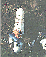
discover some of the very old mile markers. I also passed Ft. Necessity,
where Washington saved the survivors of Braddock's army. In Union, Pa.,
I finally found a bike shop and the spokes I needed to repair my wheel. Day
12: All the way up, I had been trying to turn westward, but people
always advised against it. Today, I got to pay the penalty: 71 miles of
highway 40. Because of a narrow highway with no shoulders and a lot of traffic,
I rode downhill and walked up (shoulders were added by my 1996 trip).
This was the first national highway, starting in Washington
DC and going through Washington, Pa. Along the way, I occasionally would
discover some of the very old mile markers. I also passed Ft. Necessity,
where Washington saved the survivors of Braddock's army. In Union, Pa.,
I finally found a bike shop and the spokes I needed to repair my wheel.
That evening, I reached Washington, where Aunt Betty and Uncle Harold expected
me to keep up with them as I followed their car.
Pa. State line - Washington, 71 miles, 4 hrs. + 4 hrs. walking, May
14.
 Day
13: I spend six days with my aunt and uncle. They had kept me for
a summer when I was three and my mother had had a major operation, so a
lot of strong feelings existed between us. I did not realize that this
was our last visit. They were my audience while I built new bike wheels
(not realizing that the spokes were no good). One day, I rode into Pittsburgh
to visit our old home, which had also belonged to my grandfather. On the
way, I stopped and visited my parents' childhood homes too. My uncle and
aunt "rescued" me in Mt. Lebanon when a storm blew through. Day
13: I spend six days with my aunt and uncle. They had kept me for
a summer when I was three and my mother had had a major operation, so a
lot of strong feelings existed between us. I did not realize that this
was our last visit. They were my audience while I built new bike wheels
(not realizing that the spokes were no good). One day, I rode into Pittsburgh
to visit our old home, which had also belonged to my grandfather. On the
way, I stopped and visited my parents' childhood homes too. My uncle and
aunt "rescued" me in Mt. Lebanon when a storm blew through.
Washington - Pittsburgh - Mt. Lebanon, 45 miles, May 19.
Day 14: Leaving Washington
on rolling roads mainly, and one of the steepest downhills I've even seen,
I crossed the Monongahela River at Monongahela. After crossing the Pennsylvania
turnpike, I stopped at a church when my grandfather's grandfather's grandfather
was buried. In Greensburg beyond, I had three separate amusing exchanges
with people over directions. In each case, they concentrated on telling
me what I would see if I went the wrong way. Then I started down a very
nice road with little traffic. In Pennsylvania at that time, for land to
be posted, the owner had to put a sign every x number of feet, so it was
easy for me to spot unposted land and set up my tent.
Washington - Chestnut Ridge, 70 miles, 5 hrs., May 21.
Day 15: I had been advised
to follow first highway 30 then highway 31 eastward, but I found it to
be a fairly busy and dangerous route. Often I was traveling on a broken
shoulder while streams of trucks went by; it was not an enjoyable route.
Nor was it an easy one. Part of the first day, which was pleasant, was
getting to this route. But I had to walk the first hill on 30 due to streams
of traffic and no shoulder. All I can remember of this day is vehicles
passing, although the volume of traffic changed as did my surroundings. Near
dusk, I saw some campers out in a field. I decided I better stop, so I
went down to talk. The people told me they owned the property but were leaving,
but they invited me to stay.
Chestnut Ridge - Everett, 78 miles, 5 2/3 hrs., May 22.
 Day
16: Moving eastward through Pennsylvania, I was crossing the Appalachian
Mountains. On the previous day, I had crossed only the foothills and had
squeezed along streams to miss other ridges; today I crossed three major
ridges, two of them extensions of the Blue Ridge, one right after another.
Before I neared the bottom of one mountain by McConnellsburg, I saw the
climb for the next beginning. That evening, I stuffed myself full of food
in a supermarket while a storm raged outside. Day
16: Moving eastward through Pennsylvania, I was crossing the Appalachian
Mountains. On the previous day, I had crossed only the foothills and had
squeezed along streams to miss other ridges; today I crossed three major
ridges, two of them extensions of the Blue Ridge, one right after another.
Before I neared the bottom of one mountain by McConnellsburg, I saw the
climb for the next beginning. That evening, I stuffed myself full of food
in a supermarket while a storm raged outside. Moving on towards the mountain,
I found the state park in darkness, everyone evidently supposed to find a site
in the dark without a site map or help after leaving some money. Abandoning that task, I
traveled up the road to a campground, where I was told it cost $13 to camp.
Not having any money to waste, I went
on a bit farther and found a beautiful site in the state forest.
Everett - Gettysburg, 60 miles, 4 1/2 hrs., May 23.
Day 17: Today was a very
flat day, so I had a welcome break. At Gettysburg, I visited the battlefield
briefly and then washed my clothes. That was a lucky decision, as I met
my first bike traveler there. From what he told me, I gathered that he
was living on a bike. However, he did not want me to take his picture,
saying I might post it in a hostel somewhere, and then it would cause trouble
for him. He had the biggest stack of gear on his rear carrier that I've
ever seen. I joined the Bikecentennial route at York. That night, I camped
in a town park and watched a local ball game before going to bed.
Gettysburg - Manheim, 71 miles, 5+ hrs., May 24.
Day 18: I really had trouble
trying to follow the Bikecentennial route today. There were many roads
and many turns, and the distances on the map did not agree with my speedometer.
Then the route tended to wind back and forth across some steep hills when
perfectly good roads traveled the same way with fewer hills. At one point
where I missed my turn, I ended up on a nice straight highway, so I followed
it on into Pheonixville. When I rejoined the route, I found it going through
a dangerous area near Valley Forge. However, the Bikecentennial information
about crossing the river and getting to the Philadelphia bike path were
very helpful (now the bike path begins right across the river). The upper
end of the bike path was excellent; the lower end was terrible; lots of
crowded streets and then sidewalks crowded with people. When I approached
the Ben Franklin Bridge, I knew I was supposed to get onto a walkway; however,
the one on my side was closed, and the great mass of traffic around me
pushed me towards the bridge, so I decided to go with the flow. My speed
as I approached the high point of the bridge was 27 mph; I figured that
part was due to drafting and part was due to adrenaline. I spent the next
few days with my sister Barbara and her family.
Manheim - Audubon, 130 miles, 9+ hours, May 25.
Day 19: While in New Jersey,
I pedaled to a bike shop but got lost on my way back and lost my map as
well. I was greatly intimidated by the swarms of automobiles. I was also
astonished at the cyclists, who would pass the cars queuing for the light
and would plunge through a red light ignoring the traffic. Because of my
worries, I got my brother-in-law Joe to drive me into Philadelphia to start
the trip back. I made friends with some cyclists on the way out (I had
been guided by other cyclists part of the way in), and it ended up being
a pleasant trip. I took up the Bikecentennial trail again because I was
curious and also because I had seen good camping areas, and I soon found
a pleasant patch of woods to camp in.
Philadelphia - Pine Swamp Road, 49 miles, 4 hrs., May 29.
 Day
20: Part of the time, I followed the Bikecentennial trail, and part
of the time I shortcutted. In this area between Reading and York are many
Pennsylvania Dutch, Amish, and Mennonites. There's a variation in the amount
of modern devices they use. Some have cars, some have steel-wheeled tractors,
and some use horses and buggies. Bicycles are very common too, and an acceptance
of the bicycle that even most cyclists don't have. At one point, I found
myself riding alongside and talking to a young man from this area, and
he helped me understand the differences I was seeing better. That evening,
I couldn't find a place to camp, so I just had to keep going. Finally,
I found a very small woods with no "no trespassing" sign, so I camped there.
In the morning after leaving, I looked back and saw a "Keep Out" sign facing
the other way. However, I had done no harm. Day
20: Part of the time, I followed the Bikecentennial trail, and part
of the time I shortcutted. In this area between Reading and York are many
Pennsylvania Dutch, Amish, and Mennonites. There's a variation in the amount
of modern devices they use. Some have cars, some have steel-wheeled tractors,
and some use horses and buggies. Bicycles are very common too, and an acceptance
of the bicycle that even most cyclists don't have. At one point, I found
myself riding alongside and talking to a young man from this area, and
he helped me understand the differences I was seeing better. That evening,
I couldn't find a place to camp, so I just had to keep going. Finally,
I found a very small woods with no "no trespassing" sign, so I camped there.
In the morning after leaving, I looked back and saw a "Keep Out" sign facing
the other way. However, I had done no harm.
Pine Swamp Road - Airville, 79 miles, 6 hrs., May 30.
Day 21: Today, while still
following the Bikecentennial route, I found myself back on busy highways
for a while, heading down toward Baltimore. Then I was routed onto small
roads wandering around the perimeter of the city. While I have pictures
in my mind of various places that day, nothing of special interest has
stuck in my mind.
Airville - Marriottsville, Maryland, 68 miles, 5 hrs., May 31.
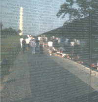 Day
22: The Bikecentennial route took me into Washington from the west,
along the Rock Creek Bike Path. I visited with Abe, was greatly moved by
the Vietnam Memorial, stopped by to see the President (he wasn't home),
and looked up at a big needle. And then it was time to go. The Mt. Vernon
bike path had some major design flaws, but its greatest problem was all
the dog walkers. These people might not want us "blocking" "their" road,
but they deliberately blocked the bike path and seemed to enjoy doing so.
A cyclist saw me at a grocery store, so I ended up sleeping at his place. Day
22: The Bikecentennial route took me into Washington from the west,
along the Rock Creek Bike Path. I visited with Abe, was greatly moved by
the Vietnam Memorial, stopped by to see the President (he wasn't home),
and looked up at a big needle. And then it was time to go. The Mt. Vernon
bike path had some major design flaws, but its greatest problem was all
the dog walkers. These people might not want us "blocking" "their" road,
but they deliberately blocked the bike path and seemed to enjoy doing so.
A cyclist saw me at a grocery store, so I ended up sleeping at his place.
Marriottsville - Alexandria, Virginia, 82 miles, 6 hrs., June 1.
Day 23: Once leaving the
Mt. Vernon bikeway (at Mt. Vernon, of course), I started running into bad
traffic, in fact, the worst I've ever encountered anywhere, and this was
the middle of the day! There was no sense of share-the-road either; these
people weren't ugly, but they were making no attempt to be careful either.
After spending a long time to go a short way, I ended up on a seldom-used
road winding out through the sticks, and had no trouble from traffic again.
Towards evening, I broke a spoke, which surprised me. I had respoked all
my wheels. I replaced the spoke and then found a camping spot right next
to the interstate.
Alexandria - Fredricksburg, 68 miles, 5 hrs., June 2.
Day 24: In the morning my
route led me through the battlefield and then on down toward Richmond on
light roads in small woods on flattish ground. This was a pleasant day's
ride, but nothing of special note happened. Towards evening, I had trouble
finding a camping site because the fences came up to the road, but I finally
found a place when I could sleep but which did not have enough room to
pitch the tent.
Fredricksburg - Beaverdam, 72 miles, 4 1/2 hrs., June 3.
 Day
25: There were many minor roads, and I was confused about my route
several times (I was now on the Bikecentennial 1776 route). However, I
did not lose much time and found myself passing Monticello on the route.
At this point, I met a cyclist who was riding the Bicentennial route a
few miles at a time but driving to the trail with his bike. Charlottesville
brought back memories of visiting my sister and her family there before
they moved to New Jersey. I decided to try to make it to the mountains,
but the road was very steep, and I worried about finding a camping place
by dark. As I passed a house, I noticed a strange bicycle parked outside.
I had discovered the home of the famous Cookie Lady. That night, I didn't
sleep much because I was too busy reading. The house she let cyclists sleep
in was filled with magazines about cycling, newspaper articles about cyclists
crossing the continent, and postcards from thousands of cyclists. Day
25: There were many minor roads, and I was confused about my route
several times (I was now on the Bikecentennial 1776 route). However, I
did not lose much time and found myself passing Monticello on the route.
At this point, I met a cyclist who was riding the Bicentennial route a
few miles at a time but driving to the trail with his bike. Charlottesville
brought back memories of visiting my sister and her family there before
they moved to New Jersey. I decided to try to make it to the mountains,
but the road was very steep, and I worried about finding a camping place
by dark. As I passed a house, I noticed a strange bicycle parked outside.
I had discovered the home of the famous Cookie Lady. That night, I didn't
sleep much because I was too busy reading. The house she let cyclists sleep
in was filled with magazines about cycling, newspaper articles about cyclists
crossing the continent, and postcards from thousands of cyclists.
Beaverdam - Afton, 89 miles, 61/2 hrs., June 4.
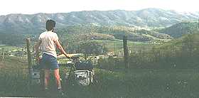
 Day
26: In the morning, I climbed up to the Blue Ridge Parkway. Soon
after entering the parkway, I was nearly hit by a motorist whipping into
the scenic outlook. I watched him as he jumped out of the car, took a wild
picture of the view, jumped back into the car, and took off. This first
section of the parkway is at high elevations and surrounded by national
forest, so it is very nice. There are some fantastic views as well as the
unfamiliar grace of riding under a canopy of trees. Since I was in very
good condition from my previous mountain areas, I did not find it challenging.
Very nice was the fact that I met some friends of the Appalachian Trail
hikers that I had met on the way up. I asked some of the people working
at the park concessions about camping policy, and I was advised to get
back far enough to be off of the parkway proper. That seemed logical to
me; that's what the AT hikers were doing anyway. That evening, I got off
from the parkway, found a grocery some distance away, and found a place
to camp. Day
26: In the morning, I climbed up to the Blue Ridge Parkway. Soon
after entering the parkway, I was nearly hit by a motorist whipping into
the scenic outlook. I watched him as he jumped out of the car, took a wild
picture of the view, jumped back into the car, and took off. This first
section of the parkway is at high elevations and surrounded by national
forest, so it is very nice. There are some fantastic views as well as the
unfamiliar grace of riding under a canopy of trees. Since I was in very
good condition from my previous mountain areas, I did not find it challenging.
Very nice was the fact that I met some friends of the Appalachian Trail
hikers that I had met on the way up. I asked some of the people working
at the park concessions about camping policy, and I was advised to get
back far enough to be off of the parkway proper. That seemed logical to
me; that's what the AT hikers were doing anyway. That evening, I got off
from the parkway, found a grocery some distance away, and found a place
to camp.
Afton - James River, 74 miles, 6 hrs., June 5.
Day 27: The next section
of the parkway began with a climb from the river at about 650 feet up to
3950 feet within ten miles of road. While making this climb, I noticed
a kitty cat walking slowly across the road. As I approached the cat got
bigger and showed absolutely no fear. Finally, I had to stop and wait for
it to finish a slow saunter across the pavement. People have said that
a Bob Cat is the size of a large house cat; I can assure you that this
animal was as large as a medium-sized dog and afraid of nothing and no
one. Later on, people would comment that the downhills must be nice on
a bicycle but the uphills murder, and I always replied that the uphill
allowed me to enjoy the woods and to see the animals, while I could never
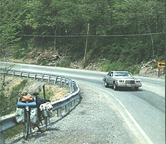
see anything racing downhill. I found more broken spokes, and I couldn't
remove my freewheel, so I had to buy a large wrench in Vinton to carry
with me.
James River - Vinton, 56 miles, 4 3/4 hrs., June 6.
Day 28: I thought that I
would make up for lost time today, but events proved otherwise. After fixing
my wheel and climbing away from Roanoke, I stopped and cooked a big lunch
at a rest stop. I hadn't covered nearly enough miles, but I was still feeling
strong, and with a good meal inside me, I wouldn't need to cook at dinner
time, so I could continue to ride later into the day. However, after some
miles, I discovered two cyclists stopped at Smart View, and a local pickup
driver trying to help them. It seems that they hadn't paid any attention
to their wheels when they had begun their trip, and now they had a lot
of broken spokes. He had fetched a wheel from his daughter's bike to help
them. So, I found myself involved in trying to repair and retrue all those
wheels. It turned out that the daughter's wheel's spokes were the wrong
length, but that mine were just right, and I had just enough. I finished
the last wheel just as it turned dark, and then I discovered that the boys
had no lights. So we camped between some young trees just out of sight
of the road. This was against parkway policy, but what could we do?
Vinton - Smart View, 44 miles, 4 hrs., June 7.
Day 29: The idea occurred
to me that I would have cycling companions for a while. It turned out that
the two young cyclists were Mennonites, so that some of the things I said
and did bothered them, and we also had other differences as well. I had
much better equipment and bicycle, so I was prepared for camping and bad
weather, while they had more money, so they could eat in restaurants or
sleep in lodgings. In addition, I was determined to pedal the whole distance,
and they saw no problem with catching rides. Under the circumstances, it's
probably surprising that we stuck together at all; however, there was only
one road, and we were traveling at about the same speed. In addition, they
sometimes needed help which only I could provide. I no longer remember
how we split up that first day, but I had the distinct impression that
they wanted it that way. At any rate, that evening I was riding down the
road when a pickup passed, and they were in the back waving at me.
Smart View - Roaring Gap, North Carolina, 78 miles, 6 1/2 hrs., June
8.
Day 30: The next day, I encountered
the same fellows very quickly. There had been some sort of change of heart,
and they felt more comfortable with me, so we rode together for a ways.
Unfortunately, the weather changed, and they found the spray from their
tires was blinding them on the steep downhill grades. So, we stopped at
some stores, and I left them and never saw them again. After I began riding
again, I felt I might have made a mistake. I was getting wet in spite of
my rainsuit, and the foggy weather increased the danger from automobiles.
However, after a stop, the weather started to clear, and I was on my way
again with less trouble. I had no problem reaching Boone that afternoon.
Roaring Gap - Boone, 60 miles, 5 hrs., June 9.
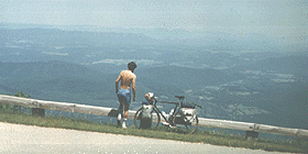
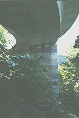 Day
31: The climb after leaving Boone was very nice, and I enjoyed walking
around at the new Linn Cove Viaduct (to put the road in, the engineers
built a long, winding bridge that follows the contours of the mountain).
However, I also found a serious problem: I now had two broken spokes and
no spokes left. Although I had wanted to visit Montreat or climb to the
top of Mt. Mitchell, I realized that I would have to make the shortest
trip I could to an Asheville bike shop. I thought about going back to Boone,
but I really didn't know for sure if there was a bike shop there, and I
hate to backtrack, so I decided to continue. Day
31: The climb after leaving Boone was very nice, and I enjoyed walking
around at the new Linn Cove Viaduct (to put the road in, the engineers
built a long, winding bridge that follows the contours of the mountain).
However, I also found a serious problem: I now had two broken spokes and
no spokes left. Although I had wanted to visit Montreat or climb to the
top of Mt. Mitchell, I realized that I would have to make the shortest
trip I could to an Asheville bike shop. I thought about going back to Boone,
but I really didn't know for sure if there was a bike shop there, and I
hate to backtrack, so I decided to continue. During the day, I revisited
the last places reached on my 1971 trip. I was amazed at how strong I was;
I was singing on the toughest climbs. That evening I took a picture of
the silhouette of the Black Mountains (which include Mt. Mitchell) against
the evening sky.
Boone - Big Laurel, 66 miles, 5 1/2 hrs., June 10.
Day 32: In the morning, I
completed the climb up the Black Mountains, and then I began the rapid
trip to the bottom of the mountain and Asheville. This is a long fast,
mostly downhill section with good views along the way. Since it was a Saturday,
there was a stream of cyclists coming up. Fortunately, my tire was not
rubbing at all, which would have been dangerous at my speeds. At the bike
shop, I discovered that my problem had been inferior spokes. I purchased
extra spokes (although nothing else broke, of course), replaced the spokes
and retrued my wheel. I was becoming expert. On the way out of town, I
stopped at a supermarket where there were large BBQ chickens for $2.50. Having
been on meager rations on the parkway and no meat, I decided to feast myself.
That afternoon, I tried climbing all the way to Mt. Pisgah, but I was not
able to do so, and I was forced to find a place to sleep along the road.
I made sure I was out of sight, and I did not pitch a tent.
Big Laurel - Mt. Pisgah, 66 miles, 5 1/2 hrs., June 11.
 Day
33: I began the day feeling a little sick. At Mt. Pisgah, I heard
an amusing tale about the man who had planned most of the trails in that
area. He was camping in his tent when a bear stuck its face in the opening.
To scare away the bear, he just shouted "BOO" as loud as he could. The
bear ran away; unfortunately, the "boo" had scared the bear so badly that
it had exhausted all of its breath into the tent. Unable to endure the
stench, the trailmaker had to sleep outside for the rest of the night. Day
33: I began the day feeling a little sick. At Mt. Pisgah, I heard
an amusing tale about the man who had planned most of the trails in that
area. He was camping in his tent when a bear stuck its face in the opening.
To scare away the bear, he just shouted "BOO" as loud as he could. The
bear ran away; unfortunately, the "boo" had scared the bear so badly that
it had exhausted all of its breath into the tent. Unable to endure the
stench, the trailmaker had to sleep outside for the rest of the night.
Later in the day, I started seeing spots in front of my eyes, and my stomach
was also bothering me. Getting off the road, I threw up violently. I buried
the mess and went on, having no more trouble. I decided that the greasy
chicken had been too much for me. Before I left the parkway at Sylvia,
I encountered another touring cyclist, riding a mountainbike with big knobby
tires. During our conversation, I pointed out that it would take less energy
to climb if he had smaller tires. While we were speaking, some younger
cyclists, dressed in full racing gear and riding ultra-lightweight machines,
started passing us. He said, "See those fellows? I've been keeping up with
them with no problem." While we were talking, a young woman ranger stopped
and started to lecture us about camping on the parkway. However, as soon
as he said he would be camping at Graveyard Fields -- a common camping
area slightly off the parkway -- she was modified and left. That night
I camped only thirty feet from the highway in a little stream bed. A walker
came by, and I could see him clearly, but he never saw me.
Mt. Pisgah - Tilley Creek, 63 miles, 5 hrs., June 12.
Day 34: After leaving the
parkway, I had started following the North Carolina bike route, and it
had an odd way of getting through the Western part of the state, taking
me south from Sylvia and then north to Franklin then almost due west to
Andrews, then after passing through Marble, back along a road heading to
highway 64 near Murphy. Most of this route was quite interesting and enjoyable,
although the part between the Nantahalla Dam and Andrews was mostly on
a new, wide boring two-lane road, and the road south out of Sylvia was
a dangerous four-lane. It was not nearly as nice as old 19, however, that
I traveled by bike in 1965 and 1971. After a really fun-filled downhill
ride into Andrews, I traveled parallel to the new 19 to Marble and then
beyond. At that point, I could have easily proceeded into Murphy on back
roads, but I chose to follow the bike route, which was a bad mistake. It
was getting towards evening, and my map showed national forest, but there
weren't even many trees. I thought about camping in a tree-filled meadow,
but a nearby, vicious, barking dog dissuaded me. When I reached 64, I found
the road suicidal, with a high cliff on one side, a drop-off on the other,
unpaved shoulders, poor sight distances, heavy traffic, and gathering night,
so I ended up walking. As I walked, I noticed cuts in the bluff. One of
them was large enough to hide me and the bike and for me to sleep in a
sitting up position.
Tilley Creek - Murphy, 74 miles, 5 hrs., June 13.
Day 35: The next day was
a traffic-filled day, all day long, as I was traveling along a four-lane.
Fortunately, there was a paved shoulder. It's impossible to enjoy the ride
when speeding cars and trucks just pass within inches, some of them passing
much closer than they have any reason too. Along the beautiful Ocoee River,
which has cut a steep winding gorge, the highway was expanded to the maximum
width possible, adding additional danger. In addition, the weather became
very hot after leaving Kentucky. However, I was able to find a nice camping
spot in the Cleveland area. This was my fourth time to camp in this area,
but I couldn't spot any of my previous camping sites.
Murphy - Cleveland, Tennessee, 72 miles, 5 hrs., June 14.
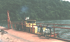 Day
36: Today was a pleasant ride. I rode into Chattanooga on highway
11, traveling through the Missionary Ridge tunnel. I took time to stop
and read at the Chattanooga public library. It was another delight to take
old 11 up around Lookout Mt. as I left town. The road taking me to South
Pittsburg was less delightful as it was hillier than I would have expected.
Before getting to that town, I took the road south that I had followed
on the trip north; however, this time I used the ferry to cross the river
to Bridgeport. When I reach my cabin in the woods that night, I was anxious
to tell others about my trip, so I rode on into Scottsboro to the informal
game club that I belonged to. However, my announcement that I had just
finished my bike trip was treated with complete indifference. Nonetheless,
that trip into town added another 28 miles for the day. Day
36: Today was a pleasant ride. I rode into Chattanooga on highway
11, traveling through the Missionary Ridge tunnel. I took time to stop
and read at the Chattanooga public library. It was another delight to take
old 11 up around Lookout Mt. as I left town. The road taking me to South
Pittsburg was less delightful as it was hillier than I would have expected.
Before getting to that town, I took the road south that I had followed
on the trip north; however, this time I used the ferry to cross the river
to Bridgeport. When I reach my cabin in the woods that night, I was anxious
to tell others about my trip, so I rode on into Scottsboro to the informal
game club that I belonged to. However, my announcement that I had just
finished my bike trip was treated with complete indifference. Nonetheless,
that trip into town added another 28 miles for the day.
Cleveland - Scottsboro, Alabama, 94 miles, 6 3/4 hrs., June 15.
This
trip had been one of the greatest experiences in my life and had cost only
$230 (about $6.40 a day or 9¢ a mile). Especially moving to me was
meeting the AT hikers, returning to my home state and childhood home, spending
time with my uncle and aunt, meeting with Amish and Mennonite people, visiting
the capital, stopping with the Cookie Lady, traveling the Blue Ridge Parkway,
and returning to the spot where my 1971 trip had ended.
Someone told me,
after I got back, that he could have made the whole trip in five days by
car. No doubt that's true; the trip would have cost much, much more and
would have been in no way as satisfying.
|